
GIS/GPS: Testing_week13
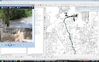
We started to import GPS data into Arcmap. The illustration shows a track of Mejicanos while mapping the economical activity. To give the tracks and gathered points of interest (including pictures) more context, we imported the given Autocad map of the Greater San Salvador.
Unfortunately we came across problems, resulting in some questions
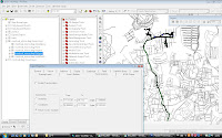
- Why presents Arc map the GPS data mirrored? What in the import process went wrong to cause this?
- How is it possible to position the Autocadmap more accurate? Now we use layer properties - transformations to transform the coordinates to the coordinates of the correct location.
We will consult our teachers in Delft, but please comment if you came across the same problems.

Unfortunately we came across problems, resulting in some questions
- Why presents Arc map the GPS data mirrored? What in the import process went wrong to cause this?
- How is it possible to position the Autocadmap more accurate? Now we use layer properties - transformations to transform the coordinates to the coordinates of the correct location.

We will consult our teachers in Delft, but please comment if you came across the same problems.


Comments (0)
Post a Comment