Showing posts with label GIS/GPS. Show all posts
8:57 PM 0 comments

GIS/GPS: Testing_week13

We started to import GPS data into Arcmap. The illustration shows a track of Mejicanos while mapping the economical activity. To give the tracks and gathered points of interest (including pictures) more context, we imported the given Autocad map of the Greater San Salvador.
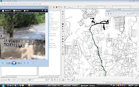

Unfortunately we came across problems, resulting in some questions

- Why presents Arc map the GPS data mirrored? What in the import process went wrong to cause this?

- How is it possible to position the Autocadmap more accurate? Now we use layer properties - transformations to transform the coordinates to the coordinates of the correct location.
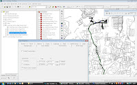

We will consult our teachers in Delft, but please comment if you came across the same problems.
11:23 PM 1 comments

GIS/GPS: Testing_week6+7

We tested/used the GPS during visiting our possible Case study locations. You can also get a good idea of the map and structure of the locations we have visited by viewing the tracks.

Paraisio de Osorio, 10-3-2009


The track of Paraisio de Osorio itself is accurate, only it seemed to be impossible to shift the time in a way that all the photos found the right location. A solution to this problem will be to synchronize the times of the camera and the GPS.


There are made many locations points at a place we didn’t mean to. Maybe the button was pressed without knowing it, next time no sitting on the GPS!

Santa Tecla, 11-3-2009


The track was pretty accurate, only when we entered a building there was some distortion.


The photos made in Las Collinas, our most important site to visit, configured with the right location points. Later on, travelling by car, the photos and the location points are not exactely put at the same place. It is probably even more important to have the time of the camera synchronized with the time of the GPS when travelling with a higher velocity.

Manantiales and Mejicanos, 12-3-2009


The track of Manantiales shows distortion at the places we stood still, this problem can be solved with the configuration, to log only when you have a minimum speed. In the Mejicanos track you see the exact same problem.

The camera was set on a different time zone then the GPS. We divided the project into two different projects, Manantiales and Mejicanos, because the time shifting gets easier with two different time frames for placing the photos accurate.

San Pedro Nonualco and Santa Maria de Ostuma, 13-3-2009


When we were in a building the track shows distortions. Next time we have to turn of the GPS when we are in a building.

The information of the GPS could be written easily into the pictures of the camera of Barbara's telephone, because the time of this camera is synchronized with the GPS.

Mejicanos, 18-3-2009


The GPS track is very accurate. The GPS information was written in the photos and they were are immediately correct placed. When we are in a building you see a little distortion. We booked a lot progress after doing all the tests and are ready to start mapping.
10:33 PM 0 comments

GIS/GPS: Testing_week6

We have tested our GPS during our trips last week. We’ve been to the market La Tiendona and to downtown.


The tracks are clear but can be improved, for example when we are standing still the GPS makes many measurements (you can see in downtown) that distort the image. With a new configuration we proceeded testing, see the track made in Santa maria de Ostuma.


Here you see distortion during entering buildings, so we have to turn it off from now on when we’ll be under a roof. But the problems of the first tracks are solved and we will proceed testing and improving the results!
4:34 PM 0 comments

GIS/GPS: seminar 2_week 3

We learned how we can work in GIS with our GPS output collected during the field trip. With the GIS we’re able to generate data by ourselves and analyze this to explore spatial patterns and relationships.
4:24 PM 0 comments

GIS/GPS: seminar 1_week2

We've got an introduction to GIS. GIS is a powerful tool for spatial research, design and planning. It is an important platform for visual representation, analysis and modeling of complex spatial environments. Also we learned how to use the GPS which we take with us on our field research.